
Trace Parsippany-Troy Hills Streets by Address
For a bounded street question, use the address to identify the parcel before looking for people. The Morris County tax search supplies the assessment-year record and parcel key. GIS shows the mapped feature and public land-use attributes. The deed index then supplies a recorded transaction trail. Each source answers a different question, so the order matters. A title name can show a recorded interest, but it does not establish that every person at an address lived there.
The safest street-directory practice is to keep a short note for each result: the exact address entered, tax year, district, block and lot, source date, and what the record actually says. If the tax page, map, and deed description do not align, pause rather than filling the gap with a guess. The official voter self-checker is for a person checking their own registration. It is not a public street-wide search.
- Use the New Jersey municipality lookup to confirm the civil jurisdiction for the exact address.
- Search the Morris County Tax Board record search by year, district, street, and number to capture block, lot, qualifier, and the returned address labels.
- Open the matching parcel in the Morris GIS Parcel Searcher and compare the map location with the tax parcel.
- Use the parcel details to narrow a BrowserView deed search by party, town, date, instrument, or parcel reference.
- For a dated historical household lead, ask a library desk for a directory volume with a street or criss-cross section, then verify it against a second dated source.
Note: A street search is strongest when it identifies a dated parcel record, not when it tries to assemble a list of private households.
Confirm Parsippany-Troy Hills Street Jurisdiction
Postal geography and civil geography can differ around Parsippany-Troy Hills. The township’s official records use several local postal labels, including Parsippany, Lake Hiawatha, Mount Tabor, Boonton, and Morris Plains examples. A ZIP is a delivery tool, not a municipal boundary. The municipality lookup is therefore the first check before a street-directory search reaches a township department or a county record.
The distinction also matters when an address result looks close but belongs in a different place. Keep the returned municipality, postal city, and property situs in separate fields. If they differ, the record has not necessarily failed. It may be showing the separate systems that handle delivery, tax assessment, and civil jurisdiction. The township’s Master Plan notes that adjacent-municipality mailing labels can affect local identity, including a Parsippany location with a Morris Plains mailing label.
The New Jersey municipality lookup is the official address-to-municipality route used before a Parsippany-Troy Hills street-directory record search.
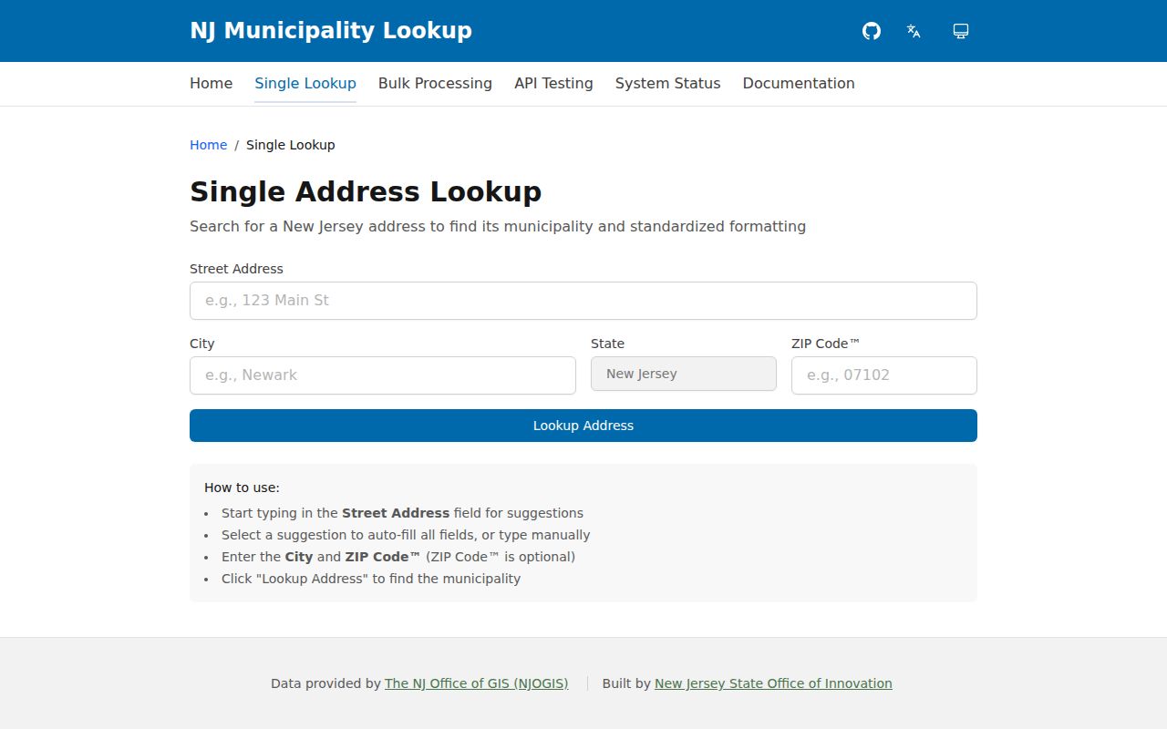
Use the USPS ZIP Lookup for a delivery check and the municipality result for township assignment. Neither result identifies a person at the address. That limit keeps the address research focused on the correct custodian.
Search Parsippany-Troy Hills Addresses
The county tax portal is the practical starting point for an address sweep. Its property-location search requires a tax year, district, and street name. House number is optional, which makes it useful when examining a narrow street segment or when a number needs to be tested separately. Preserve the tax year because a property record is an assessment snapshot, not a timeless statement.
The Tax Records Search shows the search controls used for this property-record path. A location search can lead to block and lot; those fields provide a more durable bridge to map and deed research than a name alone. If a current parcel does not resolve, test prior block and lot before concluding that the property has disappeared from the record trail.
The official Morris County tax-search page is shown here with its four address and parcel search routes.
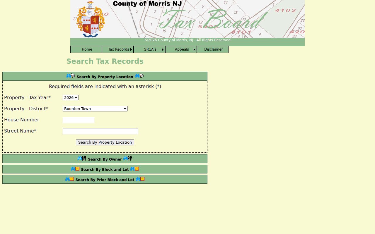
The required year and district choices help preserve the context of a returned record. A current title or mailing label should never be substituted for an undated claim about who is at a street address.
Map Parsippany-Troy Hills Street Parcels
After the tax result is saved, use the parcel map to compare the street address with the parcel geometry. The Morris GIS service exposes map-oriented fields such as location, zoning, GIS acres, construction year, building description, square footage, and dwelling counts. These describe a mapped property context. The service is not a survey, and a mapped parcel boundary is not a substitute for the legal description in a recorded instrument.
The Morris County GIS data page lists parcel, road-centerline, zoning, overlay-zoning, railroad, stormwater, FEMA, and official map resources that can explain why nearby addresses fall under different layers.
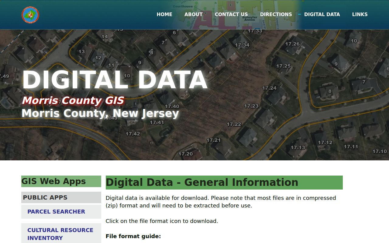
A road centerline or zoning layer can add geographic context to a Parsippany-Troy Hills address inquiry, but it does not identify occupants. Record the layer name and access date with any map observation.
The Morris GIS Parcel Searcher provides Quick Search, map view, Advanced Data Search, and a Buffer in Feet control. A small buffer can compare nearby parcels for a public land-use question. It should not be used to publish a neighbor list.
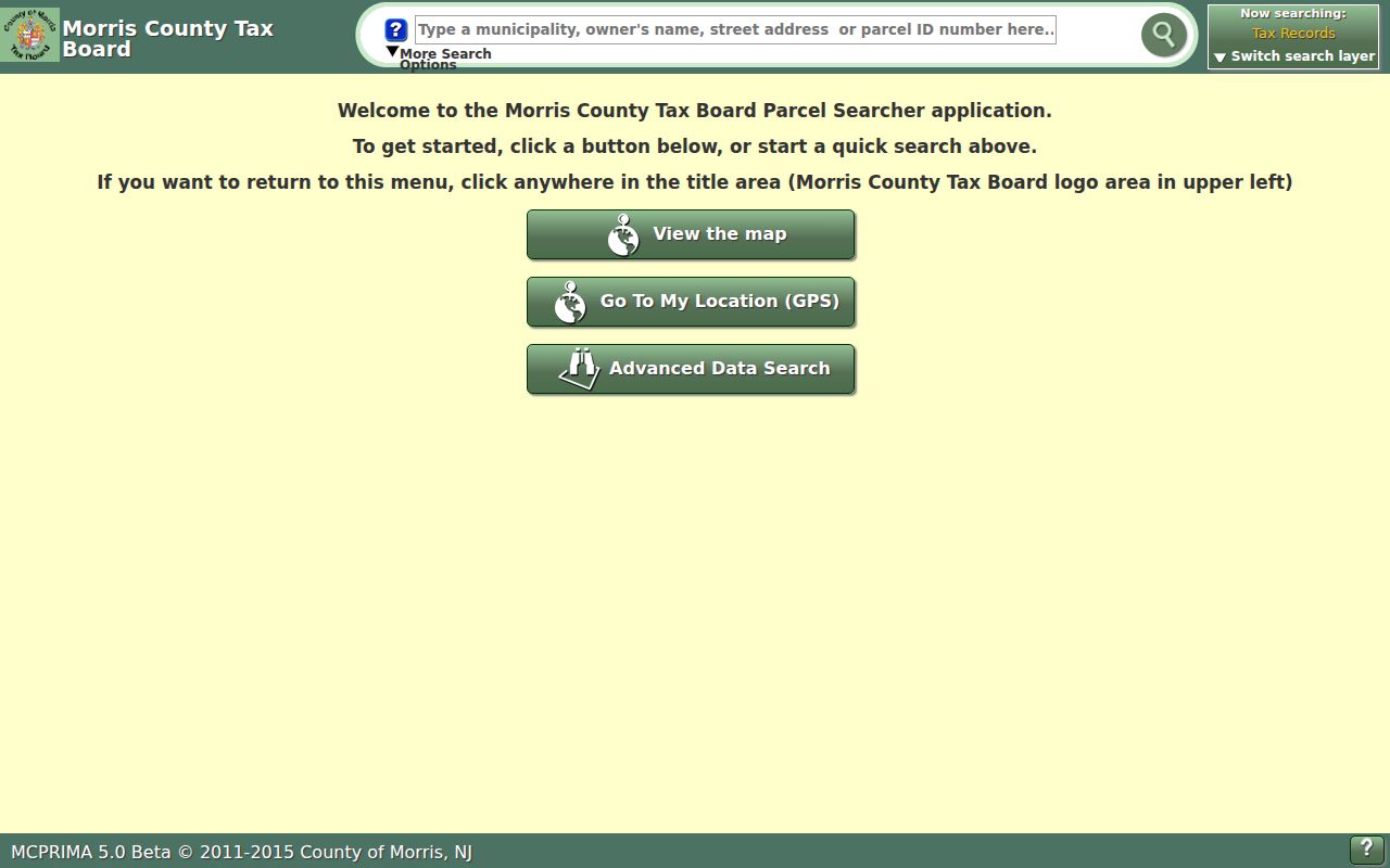
Where a modern GIS display omits owner information, Daniel’s Law redaction may be the reason. An empty field is not evidence that a parcel has no recorded owner.
Use Parsippany-Troy Hills Street Fields
Entering one field at a time makes a failed street search easier to diagnose. The tax portal separates the tax snapshot from the street and parcel fields, while the GIS application uses map and filter controls. A road-type suffix, directional prefix, spacing difference, or a prior parcel number can cause a zero result. Keep the original input as well as the successful form.
These are the field controls documented for the county tools. The fields do not turn a property search into a household directory. They are identifiers for an assessment record, mapped parcel, or a comparison of public features.
| Parsippany-Troy Hills tool | Field or control | Requiredness | Street-use purpose |
|---|---|---|---|
| Tax location | Tax Year, District | Required selects | Sets the assessment snapshot and district |
| Tax location | House Number | Optional text | Narrows a street result |
| Tax location | Street Name | Required text | Uses the situs-address street key |
| Tax parcel | Block, Lot, Qual Code | Block and lot required; qualifier optional | Links tax, GIS, and deed research |
| Prior parcel | Prior Block, Prior Lot, Prior Qual Code | Block and lot required; qualifier optional | Tests a reassigned parcel key |
| GIS map | Quick Search, filter, buffer | Dynamic app controls | Centers a parcel and compares nearby public features |
For a field mismatch, check the tax year and district first. Then try a normalized street name, a directional variation, and the prior block and lot route. The Parsippany FastTrack permit search similarly separates street number and street name, and its instructions recommend omitting the street type and testing directional variants.
The following address-keyed records form a practical coverage map for Parsippany-Troy Hills research. Read each row for the relationship it documents, not as a statement about every person connected with the address.
| Address-keyed record | Custodian | What it can show | Access and date limit |
|---|---|---|---|
| Tax assessment | Morris Tax Board and municipal assessor | Situs, block and lot, qualifier, class, and assessment-year fields | Online year, district, address, owner, and parcel search |
| GIS parcel | Morris GIS | Geometry, zoning, acres, construction, building, and dwelling attributes | Current map service; redaction may apply |
| Deed or index | Morris County Clerk | Recorded parties, instrument date, legal description, book and page | Online index from 1960; earlier records use the Vault |
| Permit or violation | Parsippany Construction Division | Application, permit, address, block, lot, status, and dates | FastTrack portal; complete start date not stated |
| Planning or zoning item | Township boards and departments | Public application, decision, minutes, map, or variance | Posted material, department contact, or a narrow OPRA request |
| Historic directory or map | MCL, MCHS, and Morristown library | Dated street labels, published traces, structures, and map context | Edition and series dependent; mostly reference or microfilm |
Tax, map, deed, permit, and historic sources should stay in separate columns in a research note. The sequence gives a street search a dated trail without converting parcel records into a private roster.
Follow Parsippany-Troy Hills Deed Records
A deed trail begins only after the address and parcel have been matched. BrowserView supports party name, document type, town, date, instrument, book and page, parcel, map, and legal-description searches. Party Name uses last name followed by first name without a comma. When a name is unknown, the tax and GIS record can supply the property information needed to narrow the county index.
The Morris County Clerk BrowserView index also displays a verification state. Treat only verified documents as verified. A status other than V/B is not verified, while R signals a replaced record and C a correction. Capture the status alongside an instrument number or book and page so a later check can identify the same record.
The BrowserView public-search portal provides the party, instrument, parcel, and map search controls used for a recorded-property trail.
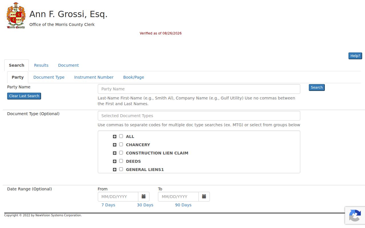
Document detail can link earlier or later instruments, but a linked document still needs to be read in context. A deed proves a recorded conveyance. It does not prove that every household member lived at the property.
Online property-index coverage is stated back to 1960. For earlier material, certified copies, or non-watermarked copies, the Morris County Records Vault holds books, microfilm, and digital images extending to the late 1700s by series. Give staff the property location, party names, approximate date, record type, and book and page when available.
Find Parsippany-Troy Hills Permit Trails
Permit records belong to the structure and project history, not a general address directory. The township’s FastTrack portal has fields for permit type and status, application date, identifiers, violation ID, contractor or agent, address, block, postal code, lot, and qualifier. It can help place a public construction or code record on a dated parcel timeline.
The Parsippany FastTrack search is most useful after the tax and GIS keys are known. Save the application or permit number, record type, date, and status. Do not infer that an applicant, agent, or contractor lived at the address. A public permit may describe a project without establishing a person’s residence.
Planning, Zoning, and Historic Preservation materials can provide additional street context through agendas, decisions, minutes, maps, and variances. The township boards and committees page identifies the public bodies that create those records. For a missing local document, send a narrow request to the department that holds it rather than using a county request for a township record.
Read Older Parsippany-Troy Hills Streets
Historic directories and maps are useful only when their date and coverage are kept visible. Morris County city directories held by the library run from 1883 to 1909, while Morristown directories run from 1885 to 1982. A volume may use Parsippany, Troy Hills, Lake Hiawatha, Mount Tabor, or another community label rather than the modern township name. Search each plausible label and record the edition before drawing a conclusion.
A criss-cross section places entries in street order. Ask the Morris County Library or the Morristown and Morris Township Library for a volume that includes one, then check the same entry in the alphabetical section and in another dated source. The historical collections and their access routes are described in the Parsippany-Troy Hills Directory Book.
For earlier physical context, the Morris County Historical Society points researchers to county maps from 1853, 1868, 1887, and 1910, and MCL’s fiche list includes Sanborn material from 1884 through 1950. A map can show a street, structure, boundary, or old number pattern. It does not establish every occupant.
Compare Parsippany-Troy Hills Geographies
One street address can have a parcel geography, a postal geography, a Census boundary, a historic-map label, and a zoning geography. This local geography issue is especially visible around Lake Hiawatha, Mount Tabor, Lake Parsippany, Rockaway Neck, and other township sections. A record filed under a local label may still need a civil-jurisdiction check before it is connected to Parsippany-Troy Hills.
County GIS layers can add road, rail, stormwater, FEMA, zoning, and official-map context. Historic transport references also matter when researching old street labels: the Morris Turnpike survey dates to 1802, the Parsippany and Rockaway Turnpike to 1806, and the Morris Canal to 1823. These are search leads for map and directory labels, not proof about a modern parcel.
Note: Keep postal city, municipality, parcel key, map layer, and source date separate whenever a Parsippany-Troy Hills address crosses record systems.
Define Parsippany-Troy Hills Address Terms
Property records use terms that look similar but serve different purposes. Reading them carefully prevents a street-directory search from treating a tax field as a title conclusion or a map label as a legal boundary. The county tools use the following terms as practical bridges between sources.
- Parcel
- A mapped unit of property that county tax and GIS systems identify with fields such as block, lot, and qualifier.
- Situs address
- The physical property location. It is the address anchor for a street search and can differ from an owner’s mailing address.
- Plat or map reference
- A recorded map or subdivision reference that can help connect a deed description to a parcel history.
- Criss-cross directory
- A directory section arranged by street and number rather than by surname, when the edition includes one.
Block and lot are useful keys, but they are not a universal replacement for the legal description in a deed. Preserve leading zeros and qualifier codes when the portal returns them. If an older document has a different parcel identifier, test the prior block and lot fields and compare the legal-description lines.
Know Parsippany-Troy Hills Street Limits
Public address records have clear boundaries. Tax and deed records can identify a parcel and a recorded party. GIS can show property characteristics and spatial context. They do not create a complete or current list of everyone at an address. DMV address information is protected under the federal Driver’s Privacy Protection Act, and utility customer lists are not a public resident index.
The statewide voter checker is for an individual’s own status. New Jersey’s statutory public voter-list route has defined fields and use restrictions, but no public street-wide checker was confirmed. Protected addresses may be redacted under the New Jersey Address Confidentiality Program or Daniel’s Law. A missing public field must remain missing.
Preserve a Parsippany-Troy Hills Street Trail
A useful street-directory note is reproducible. Record the exact input, municipality result, postal result, tax year and district, block and lot, GIS layer and date, permit or instrument identifier, and any verification flag. That small record of the search is more valuable than a copied conclusion because a later researcher can test the same links and see which source changed.
When an online source ends, use the custodian’s documented fallback. The County Clerk directs pre-1960 property work to the Records Vault, while a township-held planning or permit item belongs with the township department or a precisely described local OPRA request. For historical address traces, request the specific library reel, edition, street label, and year. Each route keeps the record tied to the office that can explain it.